Lesson Plan Overview
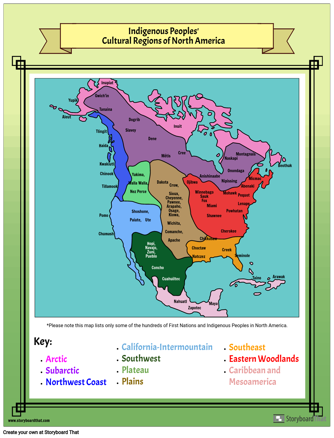
When learning about the Métis people, students may also be learning about the various cultural regions of North America. In this activity, students will color and label the map according to the regions listed in the key. They should then research where First Nations, Inuit, and Métis people live all across North America. Then, they will list the names of as many groups of people as they can in the correct region. There are over a thousand different names, so it will not be possible to do them all! Teachers may choose how many First Nations they would like students to include. A sample map is provided.
Template and Class Instructions
(These instructions are completely customizable. After clicking "Copy Activity", update the instructions on the Edit Tab of the assignment.)
Due Date:
Objective: Color the map to correctly coincide with the region names in the key. Add names of First Nations, Inuit and Métis peoples to the map in the correct regions.
Student Instructions:
- Click “Start Assignment”.
- Color the map to correctly coincide with the region names in the key.
- Add names of First Nations, Inuit and Métis peoples to the map in the correct regions.
Lesson Plan Reference
Student Rubric
(You can also create your own on Quick Rubric.)
| Proficient 4 Points | Emerging 2 Points | Beginning 1 Points | |
|---|---|---|---|
| Text / Labeling | All of the locations on the map are correct. | Missing or misplaced one to three locations. | Missing or misplaced, four or more locations. |
| Evidence of Effort | Work is well written and carefully thought out. | Work shows some evidence of effort. | Work shows little evidence of any effort. |
| Conventions | Spelling is mostly correct. | Spelling is somewhat correct. | Spelling is mostly incorrect. |
How Tos about First Nations Cultural Regions Map
How to Facilitate a Class Discussion on First Nations Cultural Diversity
Encourage students to share what they learned about different First Nations groups after completing their maps. Highlighting diversity helps students appreciate cultural richness.
Prepare guiding questions for discussion
Create open-ended questions such as, "What surprised you about where different groups live?" or "How do you think geography influences culture?" Guiding questions help students reflect and connect ideas.
Use student maps as visual aids
Display completed student maps around the room or use a projector. Visuals give everyone a chance to see regional differences and similarities.
Highlight key cultural features from each region
Ask students to point out traditions, languages, or ways of life unique to each region. Sharing details deepens understanding of cultural diversity.
Wrap up with respectful reflection
Invite students to share something new or meaningful they learned. Respectful reflection fosters empathy and a deeper appreciation for First Nations, Inuit, and Métis peoples.
Frequently Asked Questions about First Nations Cultural Regions Map
What is a First Nations cultural regions map?
A First Nations cultural regions map is a visual tool that shows the geographic areas where different First Nations, Inuit, and Métis peoples traditionally live across North America. These maps help students understand the diversity and distribution of Indigenous cultures.
How do I teach students to color and label a First Nations cultural regions map?
To teach this lesson, provide students with a blank map and a key of cultural regions. Guide them to color each region according to the key, then research and label where First Nations, Inuit, and Métis peoples live. Encourage them to list as many group names as possible in the correct areas.
Why is it important for students to learn about First Nations, Inuit, and Métis regions?
Learning about these regions helps students appreciate the rich diversity and histories of Indigenous peoples, build respect, and understand how geography influenced their cultures and communities.
What are some tips for making a First Nations cultural regions map activity engaging?
Make the activity engaging by using colorful materials, integrating research projects, providing sample maps, and encouraging students to share interesting facts about the groups they discover. Interactive discussions and group work can also enhance learning.
How many First Nations groups should students include on the map?
Teachers can decide how many groups to include, based on class time and grade level. Because there are over a thousand names, focusing on a representative sample from each region helps keep the activity manageable and meaningful.
More Storyboard That Activities
Métis Nation of Canada
Testimonials

“By using the product, they were so excited and they learned so much...”–K-5 Librarian and Instructinal Technology Teacher

“I'm doing a Napoleon timeline and I'm having [students] determine whether or not Napoleon was a good guy or a bad guy or somewhere in between.”–History and Special Ed Teacher

“Students get to be creative with Storyboard That and there's so many visuals for them to pick from... It makes it really accessible for all students in the class.”–Third Grade Teacher
© 2026 - Clever Prototypes, LLC - All rights reserved.
StoryboardThat is a trademark of Clever Prototypes, LLC, and Registered in U.S. Patent and Trademark Office


