Lesson Plan Overview
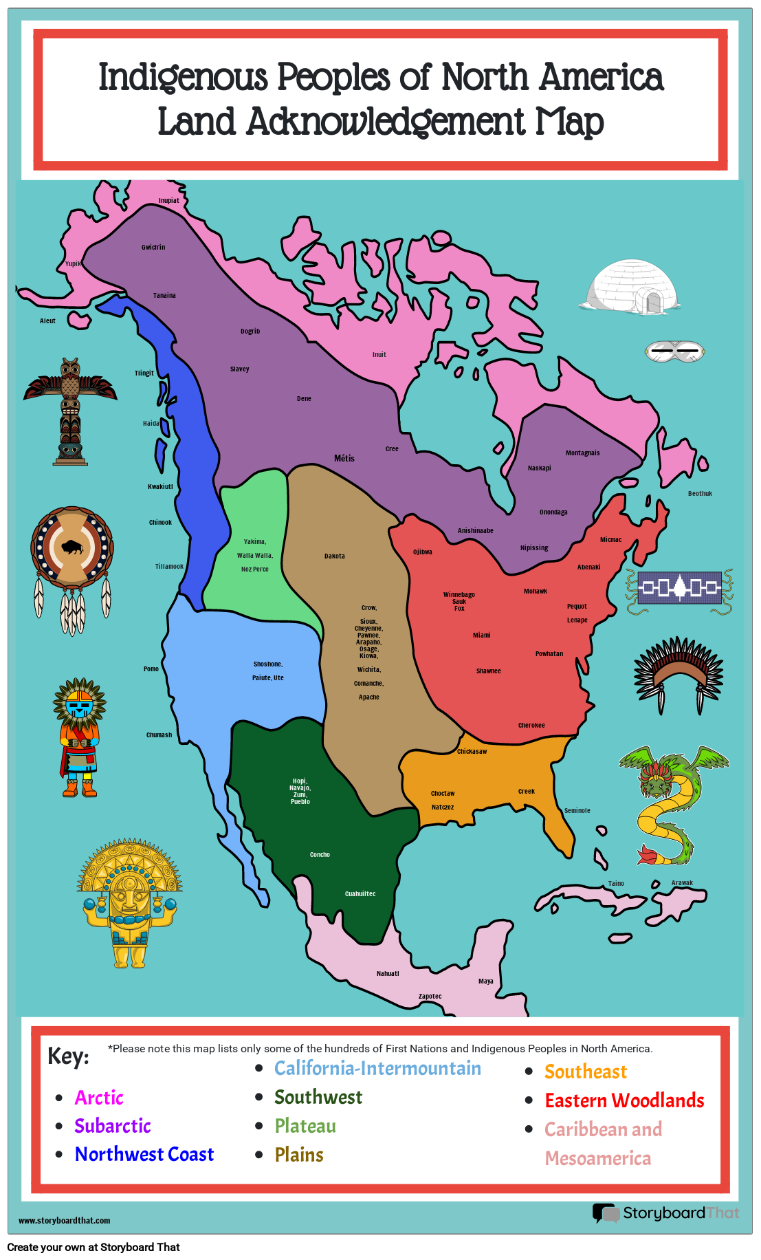
Students can create a poster sized map for a variety of projects related to U.S. history. When it comes to the Age of Exploration, it's helpful for them to acknowledge the people who lived on the land prior to European conquest. In this activity, students will label the regions and the people who lived there Students can create a map that identifies sovereign Indigenous lands today and make a comparison between what they were before colonization. They can also create a map that showcases the first European settlements across all of North America. The possibilities are endless!
Find more map posters and map worksheets to add as templates for this assignment. The worksheets can be printed out and completed by hand, or finished on the Storyboard Creator.
Template and Class Instructions
(These instructions are completely customizable. After clicking "Copy Activity", update the instructions on the Edit Tab of the assignment.)
Due Date:
Objective: Label a map of the Americas with Indigenous cultural regions, settlements, and more.
Student Instructions:
- Click "Start Assignment"
- Add text to the map to correctly label Cultural regions, settlements, and anything else.
- Add appropriate imagery.
- Save and exit when you're finished.
Lesson Plan Reference
Student Rubric
(You can also create your own on Quick Rubric.)
| Proficient 33 Points | Emerging 22 Points | Needs Improvement 11 Points | |
|---|---|---|---|
| Text | The text on the poster includes important facts, is accurate and is pertinent to the topic demonstrating a solid understanding of the subject. | The text on the poster includes some important facts, is mostly accurate and is pertinent to the topic demonstrating an emerging understanding of the subject. | The text on the poster does not include enough important facts. The information is not accurate or is not pertinent to the topic. |
| Artistic Depictions | The art chosen enhances the poster by symbolizing or illustrating important facts. Time and care is taken to ensure that the design is neat, eye-catching, and creative. | The art chosen is mostly accurate, but there may be some liberties taken that distract from the assignment. The design constructions are neat, and meet basic expectations. | The art chosen is too limited. The design appears rushed and incomplete. |
| English Conventions | Ideas are organized. There are few or no grammatical, mechanical, or spelling errors. | Ideas are mostly organized. There are some grammatical, mechanical, or spelling errors. | Storyboard text is difficult to understand. |
How Tos about Land Acknowledgment in the Age of Exploration
Plan a collaborative land acknowledgment discussion
Invite students to share their thoughts about the significance of land acknowledgments before starting the mapping activity. Guiding a group conversation helps students connect the map project to real-world respect for Indigenous communities.
Research local Indigenous nations with your class
Assist students in researching which Indigenous peoples originally lived in your school’s region. Use digital tools or library resources to find accurate, up-to-date information and make the lesson more relevant.
Integrate primary sources into your lesson
Incorporate primary sources, such as quotes, treaties, or artwork from Indigenous communities, into your teaching. This deepens understanding and encourages students to engage with authentic perspectives.
Encourage student reflection through journaling
Prompt students to write a short journal entry about what they learned from mapping and discussing Indigenous lands. Reflection builds empathy and personal connections to history.
Frequently Asked Questions about Land Acknowledgment in the Age of Exploration
What is a land acknowledgment in the context of the Age of Exploration?
A land acknowledgment during the Age of Exploration refers to recognizing and naming the Indigenous peoples and cultures who lived on the land before European colonization. It helps students understand the history and significance of these regions before and after European settlement.
How can students create a map showing Indigenous cultural regions before colonization?
Students can create a map by labeling regions with the names of Indigenous groups and highlighting their cultural areas before European conquest. Adding images and comparing these regions with today's boundaries enriches the project.
Why is it important to include Indigenous peoples in lessons about the Age of Exploration?
Including Indigenous peoples in Age of Exploration lessons provides a fuller, more accurate picture of history, recognizing cultures that existed long before European arrival and helping students appreciate the complexity of the Americas.
What are some creative ways to use map posters for teaching U.S. history?
Map posters can be used for labeling Indigenous regions, tracking European settlements, comparing pre- and post-colonization maps, and encouraging students to add images or research facts for each area.
Where can teachers find printable map worksheets or templates for this assignment?
Teachers can find map worksheets and templates online or use resources like the Storyboard Creator to print or digitally complete maps for this land acknowledgment and exploration activity.
More Storyboard That Activities
Age of Exploration in America
Testimonials

“By using the product, they were so excited and they learned so much...”–K-5 Librarian and Instructinal Technology Teacher

“I'm doing a Napoleon timeline and I'm having [students] determine whether or not Napoleon was a good guy or a bad guy or somewhere in between.”–History and Special Ed Teacher

“Students get to be creative with Storyboard That and there's so many visuals for them to pick from... It makes it really accessible for all students in the class.”–Third Grade Teacher
© 2026 - Clever Prototypes, LLC - All rights reserved.
StoryboardThat is a trademark of Clever Prototypes, LLC, and Registered in U.S. Patent and Trademark Office


